Content
Riverfront trail closure
Despite objection from hundreds of concerned residents last year, the Kentucky Transportation Cabinet announced today that it will close nearly a mile of Covington's Riverwalk (which some of us still refer to as the Riverfront Commons Trail) along the city's Ohio River banks for at least the next five years, if not longer. It's all in service of the looming Brent Spence highway and bridge expansion along nearby Interstates 71/75, which currently passes directly over the trail.
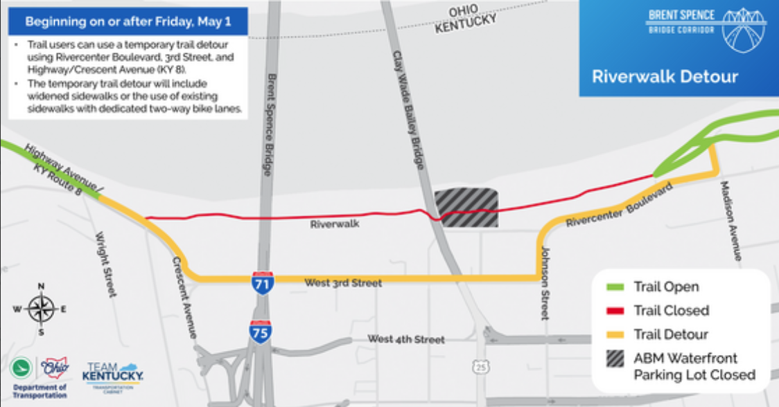
The detour depicted below will be in place until at least 2031, when officials currently (optimistically) estimate the new bridge build will be complete. It utilizes Rivercenter Boulevard and West Third Street to connect trail users from Covington Landing to the trailhead and protected trail segment on Highway Avenue leading up into Botany Hills and toward Ludlow.
"The temporary detour will meet design standards for safety and operations as outlined by the Kentucky Transportation Cabinet (KYTC). The trail detour will accommodate both cyclists and pedestrians," read an email communication on April 2 to subscribers by KYTC spokesman Jake Ryle.
Also from Ryle's email:
On Rivercenter Boulevard, the roadway will be restriped to accommodate a 10-foot-wide two-way bike lane within the existing roadway, while pedestrians will continue to use the adjacent 4-foot-wide sidewalk.
On West Third Street and Highway/Crescent Avenue, the north-side sidewalk will be widened to accommodate an 8-foot-wide shared-use path for both cyclists and pedestrians.
On Highway/Crescent Avenue, a concrete barrier will separate the path from traffic for added protection. Where warranted per design standards, a 2-foot-wide striped buffer will be incorporated to separate bicycles from traffic.
Advance signage will be installed to alert trail users of the closure and guide them along the detour.
The closure will take effect on May 1, but when the new detour's infrastructure (barriers, signage, paint, etc.) will be in place was left unclear.
Highway project putting non-highway users at risk
While these detour measures are better than nothing at all, they do not come close to the sort of accommodations Riverfront Commons Trail users have become used to and rely on.
Covington’s segment of the Riverfront Commons trail makes up roughly a mile of the 11.5-mile shared-use path that will connect Ludlow to Fort Thomas by way of Covington, Newport, Bellevue and Dayton. KYTC’s current plan will:
Force trail users onto dangerous, high-speed roads;
Create hazardous conditions at construction entrances;
Increase travel distance for current route users;
Limit recreational and commuter access to Scribble Park and other parkland;
Reduce community access to natural spaces, and more.
The more than 230 letters KYTC and city leaders received more than a year ago now did not stop the closure outright, but it seems they might have made a small difference. The most recent detour imagery has excluded a proposed detour segment that utilized the hotel and storefront parking lots, a feature CTSD strongly opposed due to parking lots being well-documented for inattentive and other dangerous driver behavior.
That said, questions about the trail segment's long-term future (that is, what it will even look like when/if it does reopen in 2031 or later) remain unanswered.
A Vision for a Better Brent Spence
An improved Brent Spence corridor doesn't have to be a 16-lane mega-freeway built for just for cars and drivers.
Take a Look